The Department of the Environment's Ambient Air Monitoring Program operates a radar wind profiler and radio acoustic sounding system network. Department meteorologists use this network to monitor winds and temperature at many levels aloft in the atmosphere to identify weather conditions related to air pollution. This information is used in the formation of daily
air quality forecasts and for research into air quality characteristics, including the effects of air pollution transported from other states on Maryland’s air.
The
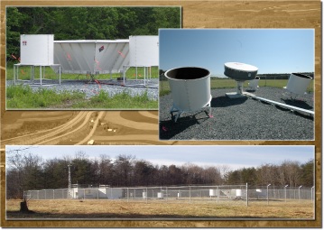
current network consists of three sites: Horn Point on the Eastern Shore, HU-Beltsville at
Howard University's Beltsville campus in central Maryland, and Piney Run in western Maryland. Horn Point and Piney Run are near the laboratories of
University of Maryland Center for Environmental Science.
Want to see and hear one in action? Watch our
Horn Point video. A radar wind profiler (RWP, the large drum in the center of the video) measures wind speed and direction at various altitudes. A radio acoustic sounding system (RASS, the four cylinders and the sound heard in the video) is collocated with each radar wind profiler and measures temperature.
Measuring winds aloft at low levels of the atmosphere provide valuable information related to air quality, including the detection of the nocturnal low level jet (NLLJ). The NLLJ is a fast-moving stream of air that flows from the southwest into Maryland, continuing northeastward. At times, it reaches
as far south as North Carolina and as far north as Massachusetts. The NLLJ forms between the Appalachian Mountains and the Atlantic Ocean during the late night and early morning hours under certain weather conditions, most often in the summer. This is thought to be one of the weather features responsible for transporting ozone pollution and its precursors at roughly 200 to 1,000 meters above the surface into Maryland which means that much of Maryland's air pollution can come from upwind states. Temperature measurements provide further insight into air quality conditions by detecting when near-surface temperature inversions form which can lead to stagnation and pollution accumulation, among other conditions.
Technical Information
Data from the Department's RWP/RASS network is shared with National Oceanic and Atmospheric Administration Earth System Research Laboratory's Meteorological Assimilation Data Ingest System (NOAA/ESRL/MADIS) as part of the Cooperative Agency Profiler network (CAP). Real-time and historical data can be accessed through the
MADIS CAP Data Display.
Two of the Department's 915 MHz systems are
DeTect RAPTOR DBS-BL/LAP-3000 Upgrade profilers. One is a DeTect RAPTOR VAD-BL profiler (Horn Point). All of them operate with four beam directions and report 30-minute average wind data every 6 minutes. These RWP measurements begin at about 100 meters above ground level (AGL) up to about 2,500 to 4,000 meters AGL in the atmosphere. In general, RWPs function by sending out radio waves at fixed levels into the atmosphere along each of its antenna's beam directions. Small amounts of the signal are then scattered back to the antenna. By determining the Doppler frequency shift, wind speed and direction are computed.
RASS measures a type of temperature called virtual temperature from about 100 to 200 meters AGL. Virtual temperature is the temperature that dry air must be in order to match the density of air with moisture. It sends out pulses of acoustic (sound) waves vertically from four speaker drums. The propagation speed of these sound waves depends on the temperature and moisture of the atmosphere. The backscattered waves can then be used to calculate virtual temperature. Additionally, the RWP/RASS generate other useful data for advanced analysis such as radial velocity, vertical velocity, signal-to-noise ratio, and spectral width. More technical information on RWP/RASS can be found at the
NOAA/ESRL.
Latest Wind Charts
Shown below for each station are the latest time series charts of winds at various heights aloft using wind barbs.
Wind barbs are symbols that indicate wind speed and direction, where a wind direction of 360 degrees (or an upward-pointing barb) indicates wind blowing from the north. Time along the chart's x-axis is shown in units of UTC, or GMT, where 15 UTC is 10 a.m. Eastern Standard Time (EST = UTC - 5).

