Air quality forecasts provided by the Maryland Department of the Environment (MDE) are available through a variety of online sources such as
AirNow,
Clean Air Partners, National Weather Service, and here on the MDE's website. Real-time air quality information can be found using these online sources in addition to the
Current Air Quality Conditions Map. Air quality notifications can also be sent to your inbox by signing up for AirNow's
EnviroFlash. The
Clean Air Partners and
AirNow apps also deliver real-time air quality conditions and forecasts to your smartphone.
What actions should be taken when poor air quality episodes are forecasted? The
Air Quality Action Guide can help you choose appropriate actions to reduce your exposure to air pollution and to actively participate in minimizing air pollution levels. Remember to do your share for cleaner air!
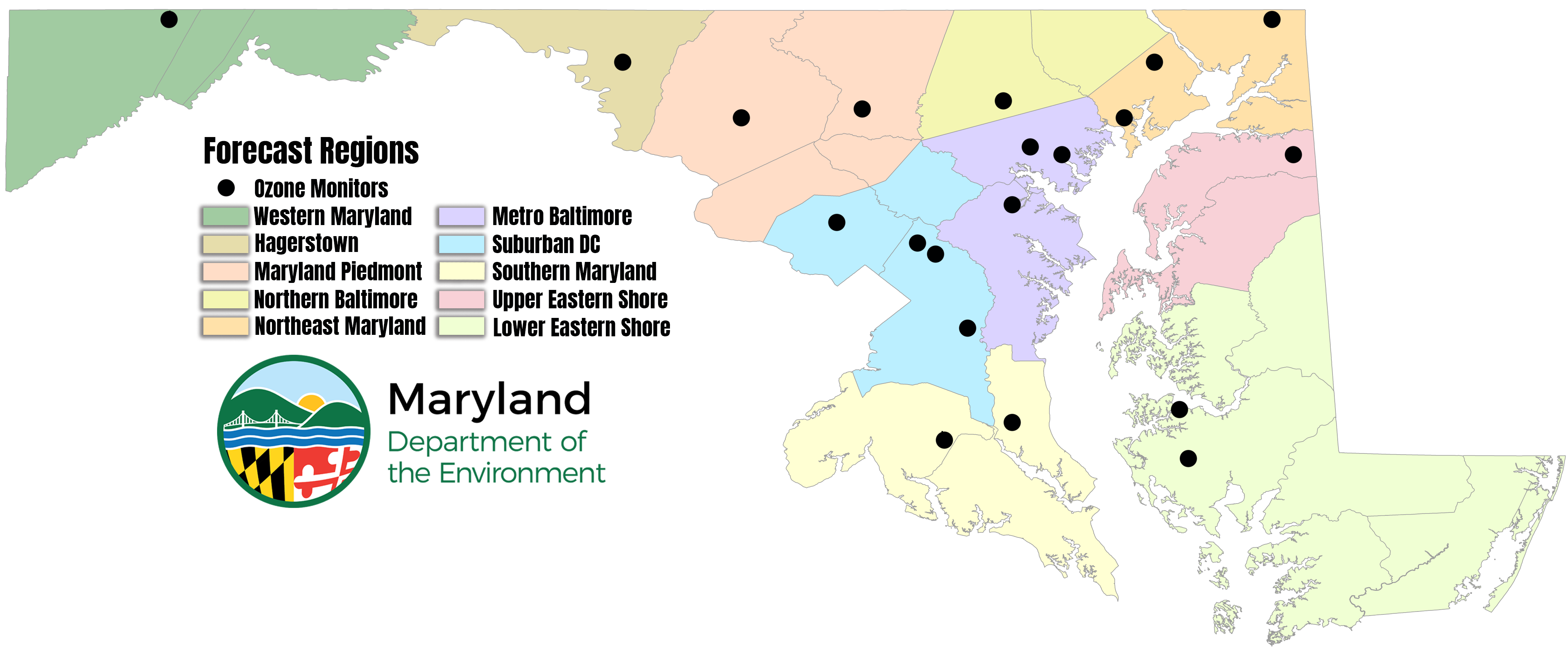
MDE offers 3-day air quality forecasts across ten Maryland regions. These forecasts are available year-round for
fine particle pollution and during April - September for
ground-level ozone pollution. Ozone can be a public health concern from late spring through the early fall months as a result of plenty of sunlight and hot temperatures. These air quality forecasts and discussions are prepared by MDE meteorologists in partnership with
Metropolitan Washington Council of Governments (MWCOG), DC Department of Energy and Environment (DOEE), and
Virginia Department of Environmental Quality (VADEQ).
The ten regions below each receive a forecast from MDE meteorologists for fine particles and/or ozone, depending on the time of year. These regions were implemented in Spring of 2022.

Western Maryland Region (monitor: Piney Run)
This region represents Garrett and Allegany Counties in Western Maryland. The higher elevations in this region have different air quality characteristics than the valley areas around Hagerstown.
Hagerstown Region (monitor: Hagerstown)
A distinct airshed exists from Hagerstown, MD to Winchester, VA along interstate I-81 and several small cities there-in. The confined nature of the valley, with mountains on both sides, makes the valley susceptible to potential poor air quality under the right conditions, distinct from higher elevations adjacent to the valley.
Maryland Piedmont Region (monitors: Frederick, South Carroll)
This region is a transition from the higher terrain to the west and lower coastal plain to the southeast. The region is typically representative of regional air quality and not typically susceptible to heavy urban plumes of pollution, making it distinct from other areas.
Northern Baltimore Region (monitor: Padonia)
The higher elevation north of Baltimore is above the coastal plain, making the region less susceptible to poor air quality than at the lower elevations except during the right meteorological conditions. With population density relatively lower in this region, poor air quality typically stems from long range transport from out of state and transport of the Baltimore pollution plume.
Northeast Maryland Region (monitors: Edgewood, Aldino, Fair Hill)
Northeastern Maryland is particularly susceptible to air quality issues related to Chesapeake Bay “Bay Breezes". Air pollution from Baltimore or activity on the Bay may be pushed northeastward, impacting only this region and sparing others due to the localized meteorology (winds) of the Bay.
Metro Baltimore Region (monitors: Essex, Lake Montebello, Glen Burnie)
The Baltimore area has an abundance of air pollution sources due to industry, power plants, and greater population density in and around Baltimore City. This region may be impacted by its own pollution during atmospheric stagnation, and from polluted “Bay Breezes".
Suburban DC Region (monitors: Rockville, HU-Beltsville, Beltsville CASTNET, Howard County Near-Road, PG Equestrian Center)
Typical surface flow is from the west and/or southwest, particularly in summer, making this semi-circle to the east of DC an area susceptible to air pollution from the greater DC and northern Virginia area.
*Howard County Near-Road measures fine particles but not ozone.
Upper Eastern Shore Region (monitor: Millington)
The Upper Eastern Shore of Maryland occasionally finds itself in the plume of the I-95 corridor from Washington DC to Baltimore. The Baltimore plume especially can hit this northern area under the right conditions, often avoiding the Lower Eastern Shore Region.
Lower Eastern Shore Region (monitors: Horn Point, Blackwater National Wildlife Refuge CASTNET)
With distinctly different meteorological and air pollutant influences than the Upper Eastern Shore, the Lower Eastern Shore has its own airshed, and its own forecast region.
Southern Maryland Region (monitors: Southern Maryland, Calvert)
Mostly rural and outside the DC pollution plume, air quality in Southern Maryland is unique and often much cleaner than other areas of the greater DC area.
Why Forecast for 10 Regions?
The scope and character of air quality events in Maryland has drastically evolved in the last two decades. Air quality historically exceeding federal standards over large areas is now a rarity. Instead, smaller areas experience infrequent exceedance events. Maryland's investments in scientific research that precipitated this cleaner air now afford the ability to forecast localized areas of poor air quality. An air quality forecast methodology that reflects the contemporary environment also better informs Maryland public health decisions. Changing the forecast methodology better serves the citizens of Maryland.
Technology has also advanced over the last two decades. Information technology and communication have undergone significant transformations. Affordable small sensors and new satellites can identify localized air quality hot spots. Changes to the MDE forecast protocol will keep MDE ahead of and embrace these developments.
Finally, health protection is the primary purpose of air quality forecasting. Contemporary events with ozone and/or fine particles exceeding the National Ambient Air Quality Standards (NAAQS) only occur at one or two, often adjacent monitors. These circumstances do not justify broad poor air quality health alerts, and do not reflect regional contemporary changes in air quality. Air quality alerts do not eliminate traffic jams, shut down industry or turn off HVAC. The new forecast region format can detail where those activities may produce poor air quality. These ten regions enable a health focused approach to air quality forecasting and will facilitate action on a personal level to protect health and wellbeing for all Maryland's citizens.
