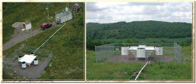
 The Department of the Environment operates an air monitoring site located near Frostburg, MD called Piney Run. This site has been established since 2004. The elevation of the Piney Run site is 781 meters (2,563 feet) above mean-sea-level. This site is on top of a local mountain peak at the Piney Reservoir, amongst other peaks on the Allegheny Plateau in Garrett County. The purpose of this monitoring site is to track the impact of interstate pollutant transport on air quality in Maryland. The location is considered ideal for measuring regional background pollutants due to its high elevation and rural setting in the State's western boundary.
Piney Run is part of several national monitoring networks including the Interagency Monitoring of Protected Visual Environments (IMPROVE), the National Atmospheric Deposition Program (NADP), the National Trends Network (NTN), and the Mercury Deposition Network (MDN). Piney Run was also a part of the Rural Aerosol Intensive Network (RAIN) which focused on haze-related measurements in partnership by the Mid-Atlantic/Northeast Visibility Union (MANE-VU) regional planning organization. However, RAIN no longer exists as a formal entity.
More on the Air Monitoring Network
Contact Us
If you have any questions, please contact Janice Lafon at
410-537-3280 or e-mail at
[email protected] so that she may direct your inquiry.