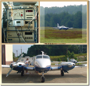
 Measuring aloft regional air pollution using an aircraft is part of the Regional Atmospheric Measurement Modeling and Prediction Program (RAMMPP) at the University of Maryland at College Park (UMD). The research being conducted through RAMMPP has been carried out through a partnership between the Department of the Environment and UMD's Department of Atmospheric and Oceanic Science since 1995. Aircraft is useful in sampling air quality because they can measure not only vertical profiles by flying a wide spiral pattern above an airport, but they can also sample across large distances by flying transects between airports. The aircraft is tilted with a tube that protrudes from the airplane body into the surrounding air. The tubing then draws an air sample into the aircraft where instruments measure for a variety of pollutants including ozone, particles, SO2, NO2, NO, CO, and various meteorological parameters. This project is typically carried out during the summer months when the Department forecasts poor air quality. The aircraft trace gas profiles and transect has helped the Department gain greater insight into the pollutant concentrations aloft as they are transported into Maryland.
The fully narrated 3-D animation below showcases how aircraft data are being utilized along with emissions, meteorological data, and other measurement platforms to visualize the westerly ozone pollution transport from the Ohio River Valley into Maryland on August 13, 2005.
