 |
Introduction
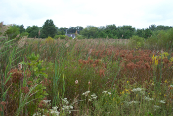
The Cloverfields I site is a 2.9 acre forested wetland creation located within the Chester River Area - Eastern Bay Area (02-13-05-01) watershed of Queen Anne’s County.
|
Construction
In Fall 1992, the Nontidal Wetlands and Waterways Division and Queen Anne’s County Department of Public Works converted this agricultural area into wetlands. The site was planted in 1993, 1994, 1996, 1997, 1998, 1999, and 2000.
|
Status
The area has developed into a densely vegetated wetland. While there are some portions of the site developing into forest, the dominant plant is the invasive species Phragmites. Partly for this reason, when MDE scored this site using the newly developed Mitigation Site Scoring Method, the site received the low score of 64/100. With that said, the site still provides some decent wetland functions, including water quality improvement through removal of nutrients, sediments, and other pollutants.
|
This site is located on school property, so access is limited. Click here to see an aerial photo and location information.
Back to Wetland Restoration, Preservation, and Mitigation page