Introduction
All Maryland counties and 92 municipalities participate in the National Flood Insurance Program (NFIP). This program makes flood insurance available to property owners in participating communities. In return, local governments must adopt ordinances to manage development within 100-year floodplains to prevent increased flooding and minimize future flood damage. Floodway and Flood Insurance Rate Maps (FIRM) published by the Federal Emergency Management Agency (FEMA) are used to delineate the 100-year floodplain and identify regulated land.
MDE cooperates with FEMA to provide assistance to all communities participating in the NFIP. A Model Floodplain Management Ordinance, meeting all state and federal regulations and containing recommendations for improved management of floodplains, has been adopted widely by communities participating in the NFIP.
Floodplain Functions
Floodplains perform important natural functions, including temporary storage of floodwaters, moderation of peak flows, maintenance of water quality, groundwater recharge, and prevention of erosion. Floodplains also provide habitat for wildlife, recreational opportunities, and aesthetic benefits. These characteristics of floodplains and associated wetlands should be preserved and enhanced.
Floodplain Zone
Maryland counties and towns may have one or more of the following floodplain zones:
- Nontidal floodplains consist of the floodway and floodway fringe along rivers, creeks, and streams. The floodway carries the higher velocity water, while the floodway fringe is subject to shallower flooding from lower velocity water. They are designed as "A" zones on the FIRM. Floodways usually are shown on special Floodway Maps.
- Tidal floodplains consist of areas subject to coastal or tidal flooding by high tides, hurricanes, tropical storms, and steady on-shore winds. Tidal floodplains are also designated as "A" zones on the FIRM.
- Coastal high hazard areas consist of coastal shorelines subject to high velocity wind and wave action in addition to tidal flooding. They are designated as "V" zones on the FIRM. Buildings in V zones must meet more stringent standards because of the forces they must withstand.
Permits
The NFIP requires counties and towns to issue permits for all development in the 100-year floodplain. Development is broadly defined to include any man-made change to land, including grading, filling, dredging, extraction, storage, subdivision of land, and the construction or improvement of structures. If state and federal permits are required, development may not begin until all necessary permits are issued. Proposed development must not increase flooding or create a dangerous situation during flooding, especially on another person's property. If a structure is involved, it must be constructed to minimize damage during flooding.
Avoidance and Minimization
The Model Ordinance requires that the local permitting official work with an applicant to avoid development in the floodplain wherever possible. If unavoidable, the effects of development must be minimized.
Flood Protection Setback
Flood damage may be minimized by requiring development to be set back 100 feet from the top of the banks of all FEMA mapped water courses and 50 feet from unmapped streams. Where the floodplain is narrower than the setback requirement, the setback ends at the floodplain boundary. The setback area is a "no build" zone which preserves the natural functions of the floodplain. Certain exemptions are allowed and local officials may consider variances.
Elevation of Structures
Damage to new and substantially improved floodplain structures is minimized by elevating the lowest floor of occupied areas one foot above the level of the 100-year flood. Enclosed areas below this are strictly limited in use and are vented to allow flooding without significant damage. Minor additions in nontidal floodplains must also be elevated. This requirement applies to all electrical devices (heat pumps, furnaces, air conditioners, hot water heaters, etc.), plumbing devices (toilets, sinks, tubs, showers, etc.), and gas appliances. All structures must be firmly anchored to foundations to prevent flotation and lateral movement.
Additional freeboard elevation will help defer repair costs when flood waters exceed minimum structural elevation levels. Freeboard is an extra amount of elevation above the 100-year flood elevation added for an extra measure of protection. It helps accounts for uncertainties such as floods greater than the 100-year floor, errors in measurement, sea level rise, and subsidence, and it lends additional protection to structures.
 |
|
This is an example of elevating utilities in the lower levels of homes in the floodplain. |
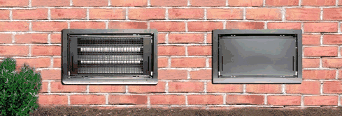
Water Equalizing Vents
Enclosed areas below the level of the 100-year flood must be vented to allow water to move freely to equalize pressure on both sides of the wall. One square inch of vent opening; is required for every square foot of area enclosed below flood level. The vents must be within one foot of grade. Areas below flood level can only be used for parking of vehicles and limited storage.
|
|
|
Lower levels of building structures need to be properly sealed
or vented so that water can flow out as easily as it flowed in. |
Elevation Certificates
To verify that a building has been properly elevated, counties and towns require the completion of an Elevation Certificate by a professional engineer or surveyor. After the lowest floor is in place, its elevation above sea level is determined by a survey. This form is part of the permit record and must be submitted before the building may be occupied legally.
Accessory Buildings
Small accessory buildings (garages and sheds) 300 square feet and under need not be fully elevated as long as they are anchored and have water equalizing vents and a Nonconversion Agreement is signed. Larger accessory buildings may be allowed without full elevation, provided certain conditions are met and a Declaration of Land Restriction is recorded to prevent future conversion to habitable space.
Floodways
Floodways should be reserved to carry deeper, high velocity waters during the 100-year flood. Ordinances do not allow new buildings or fill in the floodway. Any development that impedes floodwaters or causes any increase in water surface elevations during the 100-year flood is prohibited. Existing buildings can only be replaced or substantially improved by staying within the existing footprint. Minor additions must be elevated on pilings or columns.
Coastal and High Hazard Areas
Where additional flood hazards due to wind and wave action exist, buildings must be elevated on pilings or columns so that the bottom of the lowest supporting member of the lowest floor is at least one foot above the level of the 100-year flood. Areas below are kept open to allow free movement of water under the building, or can be equipped with breakaway walls designed to collapse without damage to the building's support system.
Manufactured Homes and Recreational Vehicles
New manufactured homes are not allowed in floodways or coastal high hazard areas. In other floodplain zones, manufactured homes have the same elevation requirements as other new construction. Foundation pilings or columns must be reinforced and the structure must be firmly anchored to prevent flotation or movement. Recreational vehicles are allowed on flood-prone sites without full elevation if licensed, highway ready, and in place for no more than 180 days.
 |
|
Displaced trailer from floods in 1996. |
State Permits
In addition to local permits, activities in the 100-year nontidal floodplain require State Waterway Construction Permits, and activities within 25 feet of or in nontidal wetlands require wetland permits from Water and Science Administration (WSA)/Maryland Department of the Environment (410-537-3745). Activities that may change tidal wetlands require Tidal Wetlands Permits from WSA (410-537-3837). To get applications for any of the above State permits, call 1-800-876-0200. Enforcement assistance can be obtained by calling WSA at (410) 537-3510 or 1-800-922-8017.
Further information on the requirements for floodplain development or map information can be obtained from your local permit office or from the State Coordinating Office of the NFIP, Water and Science Administration, Maryland Department of the Environment, (410) 537-3775.
Maryland Department of the Environment
1800 Washington Blvd.
Baltimore, MD 21230
(410) 537-3000
www.mde.maryland.gov
