Definition of Drought
Maryland uses the U.S. Army Corps of Engineers’ definition of drought, which states, "droughts are periods of time when natural or managed water systems do not provide enough water to meet established human and environmental uses because of natural shortfalls in precipitation or stream flow".
It is important to keep in mind that, while maintaining water supplies for human use is an important aspect of drought management, drought can also have many other dramatic and detrimental effects on the environment and wildlife. For instance, water suppliers using surface water sources must remain vigilant to ensure that sufficient flow remains in the rivers to meet other environmental needs. These indicators are designed to ensure that Maryland considers all potential impacts of extended periods of dry weather when evaluating drought conditions.
Indicators
In order to monitor potential drought conditions in a uniform manner across the State, Maryland uses four indicators of water sufficiency. The indicators are based on the amount of precipitation and the effect of the precipitation (or lack of precipitation) in the hydrologic system. These indicators include:
- Precipitation levels
- Stream flows
- Ground water levels, and
- Reservoir storage.
Indicators are evaluated by comparing current conditions to natural conditions within the period of record. In this way, it can be determined if a current deficit is within a commonly experienced range, or whether it is unusually large.
Precipitation
Precipitation amounts are reported by comparing current precipitation amounts with historical precipitation values as a percent of normal precipitation. Comparisons are made for each county using data prepared by the Mid-Atlantic River Forecast Center. The percent of normal precipitation value for a region is the average of the county values within that region. Normal is defined as the mean precipitation for a thirty-year record for the area and time period being evaluated.
Precipitation amounts are be evaluated based on the water year (beginning October 1). Water years are a natural dividing point for water supply drought as precipitation that falls in the first six months of a water year is analogous to putting money in the bank. A higher percentage of this rainfall or snowfall ends up recharging the ground water system, which sustains the stream flows and ground water levels during dry periods. Deficits during this time are more critical for later water levels than deficits during the growing season. If a precipitation deficit outside of the normal range exists at the end of a water year, the precipitation records will carry forward until a normal condition is reached.
Because the significance of a precipitation deficit changes as the water year progresses, drought stages will trigger at different percentages of normal depending upon the date of evaluation. See Table 2 for the precipitation drought triggers.
Stream Flow
Stream flow gages representing each region (except Southern Maryland) are used to measure stream flow. The 30 day average flow for the evaluation period is compared with low flows representing historical occurrence frequencies of 25%, 10% and 5% for the same date for the period of record. A 25% frequency equates to a one in four year occurrence, 10% frequency a one in 10 year occurrence and 5% frequency a one in 20 year occurrence.
Gages were selected on the basis of the availability of "real-time" data, as well as a sufficient period of record. The gages used may change from time to time based on availability of suitable stream gages. Gages are in the following locations:
- Youghiogheny (near Oakland)
- Savage River (near Barton)
- Wills Creek (near Cumberland)
- Marsh Run (at Grimes)
- Catoctin Creek (near Middletown)
- Monocacy (at Jug Bridge)
- Patuxent (near Unity)
- Deer Creek (near Rocks)
- Choptank (near Greensboro)
- Nassawango Creek (near Snow Hill)
- Susquehanna (at Marietta)
- Potomac (at Little Falls)
Ground Water Levels
Representative wells for each region are used for monitoring ground water levels. Ground water conditions are evaluated on a monthly basis. The monthly levels are compared with values equivalent to the 25th, 10th, and 5th percentiles of historical records.
Ground water levels in confined aquifers are responsive to pumping stresses at distances far removed from pumping centers. No baseline exists for measuring changes in water levels for confined systems. Therefore percentile frequencies are not available for wells in these systems. Evaluation of drought impacts in these systems are analyzed as a departure from the long-term downward trend in water levels.
The wells currently used for the evaluation of drought are:
| • GA Bc 1 (Garrett County) |
• WI Cg 20 (Wicomico County) |
| • AL Ah 1 (Allegany County) |
• MC51-01 (Kent County, Delaware) |
| • WA Be 2 (Washington County) |
• SO Cf 2 (Somerset County) |
| • WA Bk 25 (Washington County) |
• CH Bg 12 (Charles County) |
| • BA Ea 18 (Baltimore County) |
• AA Cc 40 (Anne Arundel County) |
| • HA Bd 31 (Harford County) |
• CA Fd 54 (Calvert County) |
| • HA Ca 23 (Harford County) |
• CH Dd 33 (Charles County) |
| • MO Cc 14 (Montgomery County) |
• PG De 21 (Prince George's County) |
| • QA Cg 69 (Queen Anne's County) |
• SM Fg 45 (Saint Mary's County) |
| |
|
Reservoir Storage
Reservoirs are designed to provide adequate storage when demand exceeds reservoir inflow. As the streamflows are lowest during the summer period and demand is also greatest, the most critical time begins at the onset of summer. Adequate storage is presumed enough to last for a four-month period or 120 days. The following ten reservoirs are monitored for the purposes of evaluating drought conditions:
- Loch Raven Reservoir, Baltimore City
- Prettyboy Reservoir, Baltimore City
- Liberty Reservoir, Baltimore City
- Tridelphia Reservoir, WSSC
- Duckett Reservoir, WSSC
- Seneca Reservoir, WSSC
- Jennings-Randolph Reservoir, WSSC
- Gordon Reservoir, City of Cumberland
- Koon Reservoir, City of Cumberland
- Piney Reservoir, City of Frostburg
Water supply problems in smaller reservoirs are taken into account when evaluating problems related to specific water suppliers. These reservoirs are too small to indicate overall water supply conditions.
Other Indicators
In addition to the four primary indicators, two other factors may enter into evaluating drought conditions. Some regions of the State will not be able to utilize all four of the indicators. For instance, Southern Maryland does not have any reservoir systems, so that indicator cannot be factored into triggering drought stages. In situations where there are fewer than four available indicators, the following additional tools may be used to determine drought stages.
U.S. Drought Monitor
The U.S. Drought Monitor is produced by representatives from the U.S. Department of Agriculture, the National Oceanic and Atmospheric Administration, and the National Drought Mitigation Center. It represents expert interpretation of a number of numerical measures of drought and how drought is affecting crops and wildlife. It is updated weekly and provides a wider perspective on drought conditions.
Water System Problems
Water suppliers in Maryland are responsible for monitoring and reporting to MDE their own water supply situations, including any negative impacts resulting from drought conditions. Due to conditions specific to individual systems, some water supplies may suffer negative impacts much sooner or later than others. MDE will continue to monitor drought-related water supplier problems throughout the year.
Regional Application
Drought conditions are evaluated on a Statewide, regional, and county basis. This allows for varying hydrologic conditions across the State, and provide for the most flexibility when assessing and responding to drought conditions. In addition, monitoring of water supply problems at individual systems may impact drought declarations in specific areas of the State.
Data collection points for monitoring drought indicators are located throughout the State and must be analyzed collectively in order to assess the overall severity of drought. Indicators are evaluated at all levels. For instance, precipitation values are provided on a county-by-county basis. Values for individual counties will be averaged to achieve a mean value for a region.
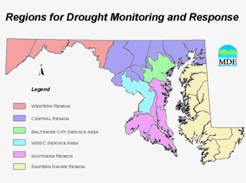
Maryland is divided into four drought regions based on the similarity of weather patterns and the primary source of water supply. These regions consist of groups of counties, which provide clear political boundaries for assessing and declaring drought. Two additional regions were added for the areas of the state that are served by the two large metropolitan systems, WSSC and Baltimore City. Although these regions cross political boundaries, it is appropriate to segregate them because the water supply issues related to these systems are unique due to the existence of reservoir storage systems. In addition, these systems are authorized to determine their own water supply availability and needs, and to assess and respond to drought conditions. The State has the authority to impose staged drought response in the two metropolitan areas should the water supply systems fail to respond appropriately. In addition, should conditions warrant, staged drought response may be imposed or revoked in individual counties.
Western Region – Allegany, Garrett, and Washington Counties
Central Region – Baltimore, Carroll, Cecil, Frederick, Harford, Howard, and Montgomery Counties except for areas served by Baltimore City or WSSC.
Southern Region – Anne Arundel, Calvert, Charles, Prince George’s and St. Mary’s Counties, except for areas served by Baltimore City or WSSC.
Eastern Region – Caroline, Dorchester, Kent, Queen Anne’s, Somerset, Talbot, Wicomico, and Worcester Counties.
Baltimore City Service Area
Washington Suburban Sanitary Commission Service Area
Baltimore City Service Area
For More Information
For more information, contact the Water Supply Program at 410-537-3702 or
[email protected]
