|
Click on photo to view larger image


|
MDE is leading the effort to evaluate drinking water supplies for the 5.3 million Marylanders and the estimated 1.4 million that will come to Maryland during the next 20 years. Two long-term studies will give Maryland the much-needed tools to ensure the sustainability of the State’s water resources while maintaining the ecological integrity of the aquatic ecosystem. The Governor’s Advisory Committee has projected that the need for increased water withdrawals in Maryland will grow 16 percent by 2030 to 233 million gallons per day.
Fully funding these studies is a top priority. The Department’s FY 2011 Proposed Budget includes an additional $1 million and Governor O’Malley included funding for the studies in his request to the Maryland Congressional Delegation for federal funding.
The Coastal Plain Water Supply Study and the Fractured Rock Water Supply Study are attempting to answer important questions, including:
-
As Maryland continues to grow, will there be enough water for both humans and wildlife?
-
How does our water use affect the environment?
-
What are the impacts of water use on streams, aquatic life, and the long-term viability of our water sources?
MDE manages the State’s water supplies through a permitting program that requires permits for most non-domestic uses. By law, MDE is required to manage the water for all beneficial uses including drinking water, agriculture, recreation, and other human needs. MDE must also manage water supplies to ensure that our rivers, streams, and bays can continue to support a wide diversity of aquatic life.
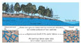
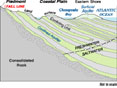
Maryland’s water supplies fall into two distinctly different hydrogeologic regions – the Coastal Plain and Fractured Rock – divided by the “Fall Line,” which marks the boundary between the two regions. In Maryland, the Fall Line closely follows the I-95 corridor with the Coastal Plain region to the east and the Fractured Rock region to the west.
The Atlantic Coastal Plain system consists of an alternating series of aquifers (generally unconsolidated sands and gravels) and confining units (finer-grained sediments such as clays) that inhibit the flow of water between the aquifers. Groundwater fills the empty spaces between the sand particles in the aquifers. Water enters as rainfall or snowmelt, and can reside in the system for long periods of time – from a few decades up to several thousands of years. Key aquifers include the Aquia, Magothy, Patapsco, and Patuxent aquifers in Southern Maryland, and the Piney Point, Aquia, Pocomoke, Manokin, Fredericka, Federalsburg, Cheswold, and Columbia aquifers on the Eastern Shore. Water levels in many of these aquifers have been declining over the years, and continued declines could reduce the water supply and threaten the viability of the aquifer.
Scientists from MDE, the U.S. Geological Survey, and the Maryland Geological Survey are studying the potential of these aquifers to meet projected water supply needs and are developing tools that will help MDE manage the State’s water supply in a way that benefits all users. The study is expected to take eight to ten years to complete.
With their early efforts, the team developed tools such as a geographically based database that allows MDE permit reviewers to identify features critical to estimating water availability, such as aquifer locations and characteristics, and locations of nearby wells. Future work will include a regional groundwater flow model that can predict the impacts of various withdrawal scenarios on the aquifers, streams, and wetlands of the Coastal Plain region, and assist MDE water managers to optimize water withdrawals in the Coastal Plain aquifer system for the greatest benefit of all users.
In the Fractured Rock region, groundwater flow is localized and controlled by local watersheds. Groundwater is found in fractures (cracks and crevices) in the rock. Water availability depends on the size of fractures, the interconnections between fractures, and the location within the watershed. As a result, wells do not consistently yield the desired quantity of water, and communities must sometimes drill a dozen or more wells to find sufficient water to meet their needs. Groundwater is a critical source of baseflow for streams, which means that overuse of groundwater can potentially affect stream ecology and aquatic plant and wildlife, especially during dry periods.
The Fractured Rock water supply study was initiated in 2009. The study will examine the relationship between healthy aquatic ecology and water withdrawals and identify aquifer characteristics that may predict higher-yielding wells. In addition, the study is looking at two research watersheds to evaluate the impacts of development and other factors on water supply. The Fractured Rock study is expected to take about five years to complete.
The Coastal Plain and Fractured Rock water supply studies will provide important management tools for MDE as the Department seeks to ensure an adequate and sustainable supply of water for its citizens while maintaining healthy and thriving streams that sustain our valuable and irreplaceable aquatic life. These studies will provide the comprehensive statewide data and scientific tools needed to ensure that water is allocated and used in a sustainable fashion without causing ecological damage.
|
